How it unfolded
As the sun rose on March 15, 2026, residents of Raleigh, North Carolina, braced for what was anticipated to be a significant weather event. The National Oceanic and Atmospheric Administration’s (NOAA) Storm Prediction Center had issued a rare Level 4 risk out of 5 for severe weather in the area, indicating a high potential for dangerous conditions.
By mid-morning, the situation escalated as several school districts, including the Wake County Public School System and Chapel Hill-Carrboro City Schools, announced closures for the day due to the impending storm threats. This proactive measure aimed to ensure the safety of students and staff as forecasters warned of damaging wind gusts expected to reach between 55 and 75 mph.
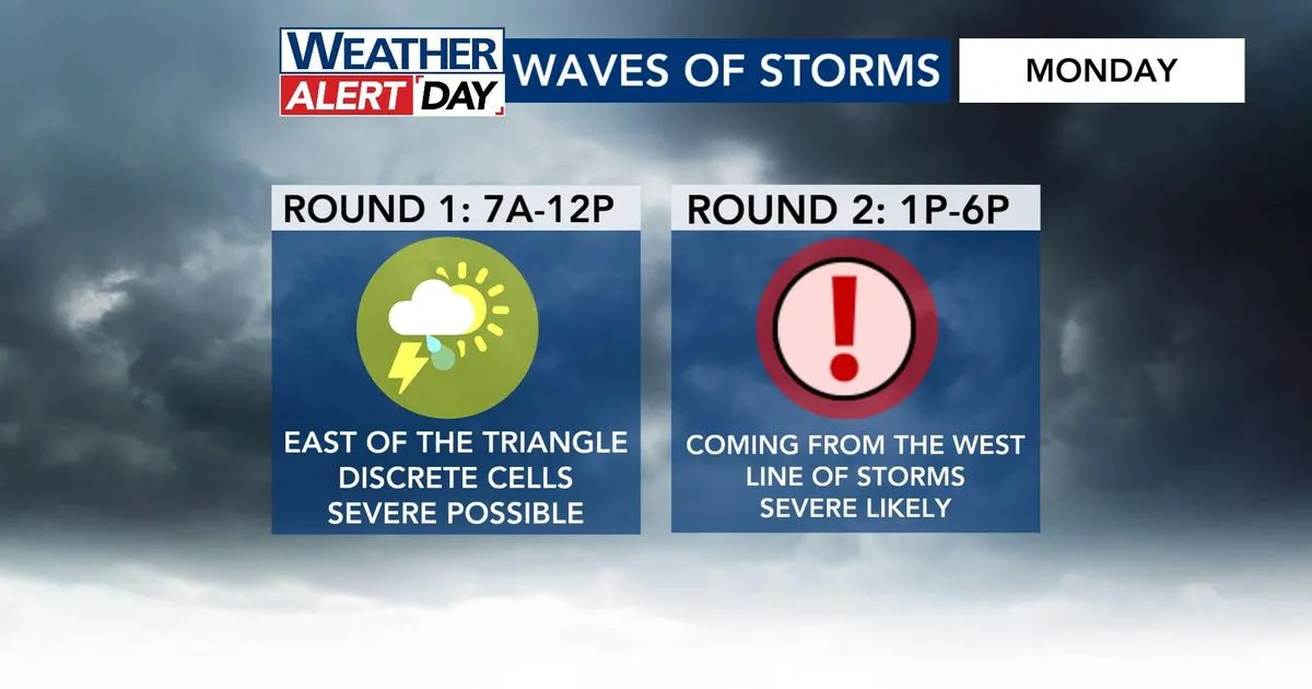
As the day progressed, the forecast indicated that the main line of storms would arrive in the afternoon, ahead of a cold front. Chris Michaels, a local meteorologist, emphasized the seriousness of the situation, stating, “Monday has the potential to be a significant weather day in our area and across the eastern U.S.” The anticipation of severe thunderstorms, hail, and even tornadoes heightened concerns among residents.
In response to the looming threat, North Carolina Emergency Management activated the State Emergency Response Team personnel and resources. Governor Josh Stein addressed the public, noting, “Unusually severe weather is moving into North Carolina, bringing a risk of damaging wind gusts, thunderstorms, hail, and even tornadoes.” This statement underscored the gravity of the situation and the need for residents to remain vigilant.
Duke Energy prepared for potential power outages by deploying thousands of line and tree workers across the state. Jeff Brooks, a spokesperson for the utility company, remarked, “This will be one of those dynamic storms that we have to watch as it evolves to see where those outage pockets are appearing, and then adjust our resources as needed to respond.” Such preparations were crucial, given that the last time the area faced a Level 4 risk was in March 2021.
As the afternoon approached, forecasters warned that the strongest storms would come in two waves, with the main event expected after 12 p.m. Residents were advised to enable emergency alerts on their phones to stay informed about the rapidly changing conditions. The potential for tornadoes added an extra layer of urgency to the situation, prompting many to seek shelter and make safety plans.
By late afternoon, the atmosphere grew tense as the first wave of storms began to roll in. Reports indicated that wind gusts in Raleigh could reach up to 74 mph, raising alarms about the possibility of downed trees and power lines. As the storm system moved across the Eastern U.S., it was clear that the impacts would be felt far beyond North Carolina, with other states also preparing for severe weather.
As the situation continues to develop, residents are urged to remain alert and follow updates from local authorities. The combination of high winds, potential tornadoes, and heavy rainfall poses a significant risk, making it imperative for everyone to prioritize safety. Details remain unconfirmed as the storm unfolds, but the community’s preparedness and responsiveness will be crucial in navigating the challenges ahead.